inquiry
Leave Your Message
0%

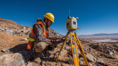
Nowadays, having reliable positioning and navigation is pretty important across lots of industries. That's why more people are turning to GNSS CORS stations. These stations give you stable reference points, which are super helpful for getting accurate positioning data. But, honestly, knowing how to use them properly makes all the difference if you want the best results.

Getting the most out of Gnss Cors Stations can really boost your data accuracy, but a lot of folks struggle with the technical side of things. Things like setting up the equipment just right, making sure the signals are strong, and avoiding interference can all impact how well everything works. It’s really important to keep an eye on these factors regularly—neglecting them often leads to results that aren’t as precise as you'd hope.

And don’t forget, the environment around your station matters too. Things like nearby buildings, trees, or other obstructions can cause errors. It’s a good idea to adapt your approach depending on your surroundings. Mistakes can happen if you’re not careful, but taking some time to fine-tune your setup and technique can make a really big difference. Staying open to learning and continuously improving your methods with GNSS CORS stations will definitely pay off in the end.

Essential Tips for Using GNSS CORS Stations Effectively?

Understanding GNSS CORS Stations: Overview and Functionality

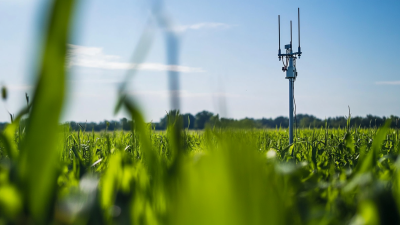
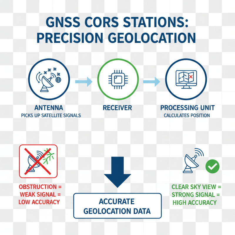
GNSS CORS stations, or Continuously Operating Reference Stations, are crucial for accurate geolocation. They provide real-time correction signals for Gnss Receivers, enhancing positioning accuracy. These stations help mitigate errors caused by atmospheric conditions, multipath effects, and satellite geometry. Understanding their functionality is key to leveraging their capabilities effectively.

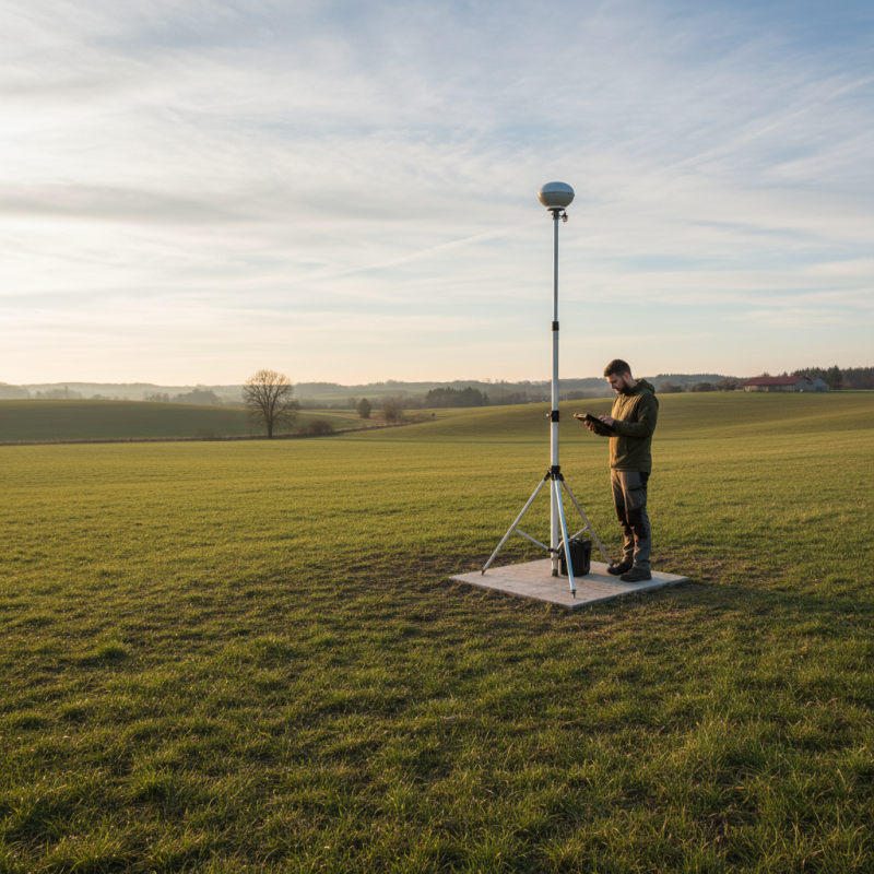
When using GNSS CORS stations, consider site selection carefully. Choose locations with minimal obstructions for optimal signal reception. Nearby large structures or trees can interfere with performance. Additionally, keep in mind that different stations may offer varying levels of accuracy. Research the specifications of each station before beginning your project.

It’s also essential to manage data effectively. Regularly check for updates to CORS data and ensure your equipment is well-maintained. This can help prevent potential issues during data collection. Implementing these tips can improve your overall experience with GNSS technology, but remember that no system is perfect. Always be prepared to adapt your approach based on specific conditions or challenges.

GNSS CORS Stations Performance Over Time

This bar chart illustrates the monthly average accuracy (in centimeters) of GNSS CORS stations over the last six months. The effectiveness of usage is reflected in the variations in accuracy, which can be impacted by factors such as atmospheric conditions and satellite visibility.

Key Components of GNSS CORS Stations and Their Roles

Essential Tips for Using GNSS CORS Stations Effectively?

GNSS CORS stations are vital for precise geolocation. Their key components include antennas, receivers, and processing units. The antenna picks up signals from satellites. It is crucial to ensure the antenna is unobstructed. This helps improve signal quality. When signals are weak, accuracy suffers.

Receivers capture satellite data and convert it into usable information. They also filter out noise. A good receiver can enhance positioning accuracy. The processing unit analyzes signal data. It integrates multiple satellite signals to provide precise results. If the processing unit is outdated, it may struggle with current satellite constellations.

Positioning corrections are essential. They help refine location calculations. However, not every correction method suits every situation. Users must assess their specific needs. This can be a complex decision-making process. Understanding these components and their roles can improve GNSS CORS station usage. Keeping equipment updated is necessary for optimal performance.

Preparing Equipment for Optimal GNSS CORS Station Use

To prepare your equipment for optimal GNSS CORS station use, start with a thorough check. Inspect all cables for wear and tear. Ensure your receiver is calibrated and up to date. This can prevent costly errors during data collection. Check battery levels to avoid interruptions. Even a small oversight can lead to significant data loss.

Next, consider environmental factors. The placement of antennas is crucial. Avoid obstructions that could block signals. Trees, buildings, and even weather can impact readings. Double-check the positioning of your asset; a slight misalignment can skew results. Don't forget to account for any reflective surfaces nearby.

Lastly, it's essential to have a backup plan. Equipment can fail. Ensure you have spare batteries and cables handy. If using a portable GNSS setup, test from different locations. This can help gauge reliability. Remember, Cors Station Gnss usage is about consistency. Small adjustments can lead to better data quality. Take the time to reflect on these details before heading out.

Best Practices for Data Collection with GNSS CORS Stations

Using GNSS CORS stations can significantly enhance data collection efficiency. Accuracy is key. Data from a recent industry report indicates that GNSS CORS stations can achieve centimeter-level precision. However, user error can negate these benefits. Ensuring proper setup is crucial. For instance, a poorly positioned Gnss Cors Station Mount may lead to unreliable data.

Regular maintenance of equipment also matters. Dust or physical obstructions can affect signal quality. Studies reveal that 15% of data inconsistencies stem from hardware issues. Users should routinely inspect their stations for wear and tear. It’s essential to remain mindful of environmental factors. Terrain and weather conditions can impact GNSS signal reception.

Data collection protocols must be followed rigorously. Many practitioners overlook the importance of proper logging. Without consistent practice, crucial data may go missing. Familiarizing oneself with best practices enhances overall reliability. Consider utilizing backup systems as a precaution. While GNSS CORS stations are robust, having redundancy can ensure data integrity, especially in critical applications.

Interpreting GNSS Data: Methods and Tools

Interpreting GNSS data can be a daunting task. Many users rely on Gnss Cors stations for accurate positioning. However, newcomers often feel overwhelmed. The complexity of data formats and outputs can lead to confusion. Proper interpretation requires a solid understanding of the data's structure and context.

Using software tools designed for GNSS CORS data analysis is crucial. These tools can help visualize data and identify trends. But not all programs are user-friendly. It's essential to choose one that matches your experience level. Some tools may have steep learning curves. Users should be patient and willing to experiment.

It's also beneficial to stay informed about best practices in data interpretation. Engage with online forums and communities. Share experiences and learn from mistakes. Sometimes, what appears as an error may teach you valuable lessons. Regularly reviewing your interpretation techniques can uncover new insights. Embrace the challenges that come with using GNSS CORS stations. They can lead to better understanding and improved results.

Essential Tips for Using GNSS CORS Stations Effectively

Tip Description Method Tools
Choose the Right Station Select stations that are close to your area of interest for better accuracy. Site Selection Online Station Lists
Understand Data Formats Familiarize yourself with the data formats provided by GNSS stations. Data Parsing Data Conversion Tools
Monitor Environmental Conditions Check for obstructions and atmospheric conditions that may affect signals. Real-Time Monitoring Weather Apps
Perform Regular Calibration Regularly calibrate your equipment to ensure data accuracy. Calibration Checks Calibration Software
Analyze with Software Use software to analyze GNSS data for better insights and reporting. Data Analysis GNSS Analysis Tools

Common Challenges in Using GNSS CORS Stations and Solutions

Using GNSS CORS stations can present several challenges. One common issue is signal interference. Urban environments often disrupt signals from satellites. Buildings, trees, and even weather conditions can affect accuracy. Users may find unreliable readings, leading to frustration. Selecting locations with clear views of the sky helps.

Data processing can also be complex. Many users struggle with interpreting the data correctly. Software tools often have steep learning curves. It’s crucial to invest time in understanding these tools. A misinterpreted dataset can lead to significant errors. Continuous training and utilizing community resources can bridge this knowledge gap.

Maintaining the equipment is key. Regular checks on hardware ensure optimal performance. Users often overlook this aspect. Faulty antennas can degrade signal quality. Additionally, keeping updates for software is vital. Many assume their systems are current, only to face unexpected issues. Regularly reassessing equipment conditions can mitigate potential problems.

Real-World Applications of GNSS CORS Data in Various Fields

GNSS CORS stations serve diverse fields such as agriculture, construction, and surveying. Farmers use these systems to improve crop yields. By accessing Precise Positioning data, they can optimize planting and irrigation schedules. This leads to more efficient land usage and reduced waste. The implementation ofNrtk Cors Gnss technology allows for real-time adjustments. However, some users face challenges with connectivity and data quality. Ensuring a stable connection can be tricky in remote areas.

In construction, GNSS CORS data facilitates accurate mapping and site analysis. Engineers rely on this information to align structures precisely. Working within tight tolerances is essential. Mistakes can lead to costly delays and rework. Yet, not all sites have effective coverage. This raises questions about the reliability of data in certain locations. Tapping into CORS data is beneficial, but users must remain vigilant.

Surveying is perhaps the most traditional field utilizing GNSS CORS. Surveyors depend on elevation and boundary data to create high-quality maps. However, the technology is not infallible. Variables like atmospheric conditions can skew results. Users must constantly evaluate their methods. Balancing precision and practicality is crucial for success in any project.

Exploring the Advantages of the Hot Sale Topcon All Metal Single Tilt Reflector Prism Set for Accurate Total Station Surveying

In the realm of surveying, precise measurements are paramount, and the use of high-quality instruments significantly enhances overall accuracy. The Hot Sale Topcon All Metal Single Tilt Reflector Prism Set stands out as an invaluable tool for professionals. This advanced reflector prism set offers exceptional durability, which is crucial for outdoor conditions where environmental factors can hinder performance. The all-metal construction ensures resistance to wear and tear, making it a reliable choice for long-term use in various surveying applications.

Professionals in the surveying industry consistently prioritize instruments that enhance efficiency and accuracy. According to a 2022 survey by the International Federation of Surveyors, over 64% of surveyed professionals indicated that the quality of measuring equipment directly correlates with project success rates. The single tilt functionality of the reflector prism allows for quick adjustments and easy handling, facilitating timely data collection during field operations. This feature becomes particularly important in fast-paced projects where timing is critical.

Moreover, the ability to achieve a high level of precision with minimal setup translates into cost savings for surveying firms. A report from the American Society of Civil Engineers highlights that utilizing high-quality equipment can reduce miscalculations, which occurred in approximately 20% of surveyed projects in previous years. By investing in reliable tools like the mentioned prism set, surveyors can significantly lower the risk of errors, thereby improving their overall operational efficiency and effectiveness in delivering projects on time and within budget.

FAQS

: What are the common benefits of using this type of service?

: Users often experience improved convenience and increased efficiency in their daily tasks. Enhanced organization can also help.

Are there any risks involved in using such services?

Yes, risks may include data privacy concerns and potential misuse of personal information. Always proceed cautiously.

How can users ensure their data remains secure?

Use strong passwords and enable two-factor authentication. Regularly review privacy settings for added protection.

What should I do if I encounter technical issues?

Try restarting the application or device. If the issue persists, contacting customer support can be helpful.

Is it easy to get started with these services?

Most platforms offer user-friendly interfaces. However, some users may face challenges during the initial setup.

How does pricing typically work for these services?

Pricing models vary. Some offer free trials, while others may require subscriptions or one-time fees depending on features.

Can users customize their experience?

Yes, many services allow for personalization. However, the extent of customization might vary significantly.

What feedback do users generally provide?

Feedback often highlights ease of use and usefulness but sometimes points to areas needing improvement.

Are updates frequent and beneficial?

Frequent updates can enhance performance and security. Users may find some updates more useful than others.

What should I consider before signing up?

Evaluate the features and costs. Reflect on personal needs; engagement might not suit everyone equally.

Conclusion

GNSS CORS (Continuously Operating Reference Stations) stations play a crucial role in enhancing the accuracy and reliability of satellite positioning systems. This article provides an overview of how GNSS CORS stations function and highlights their key components, which contribute to precise geospatial data collection. To maximize the efficacy of GNSS CORS stations, users must prepare the appropriate equipment and follow best practices during data collection.

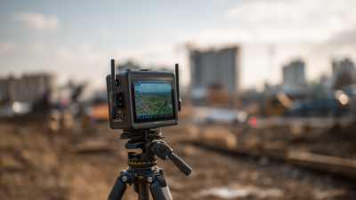
Additionally, the article discusses various methods and tools for interpreting GNSS data, while also addressing common challenges encountered in their use and potential solutions. The real-world applications of GNSS CORS data span multiple fields, including surveying, agriculture, and environmental monitoring, demonstrating the versatility and importance of these stations in modern technology.

Elena

Elena

Elena is a dedicated marketing professional at Shanghai Apekstool (APEKS), a leading provider of innovative geospatial surveying and mapping products. With a deep expertise in GNSS/GPS systems, total stations, levels, and theodolites, she plays a crucial role in communicating the core benefits and......
Previous Top 10 RTK Col Antenna Manufacturers from China at the 137th Canton Fair